



Urban development is entering a new era. For decades, growth planning was often framed around individual cities, local zoning maps, and municipal service boundaries. That approach still matters, but it no longer captures the full reality of how people live, work, commute, invest, and move across modern urban systems. In Canada and across North America, population growth, housing pressure, infrastructure demand, and climate risk are increasingly concentrated within large interconnected metropolitan networks. That is where mega-region planning becomes essential.
Table Of Content
- What Mega-Region Planning Actually Means
- Why Mega-Regions Matter More Than Ever
- Housing Supply Is the Defining Planning Challenge
- From Municipal Boundaries to Functional Urban Systems
- Infrastructure Is the Backbone of Regional Growth
- Sustainability and Climate Resilience at Regional Scale
- Economic Vitality and the Logic of Agglomeration
- The Governance Challenge: Coordination Without Gridlock
- What Effective Mega-Region Planning Looks Like in Practice
- Community Needs Still Matter at Larger Scale
- The Canadian Opportunity
- Conclusion: Planning at the Scale of Reality
Mega-region planning is not simply a bigger version of city planning. It is a strategic lens for understanding urban development at the scale where housing markets, labour markets, transportation systems, supply chains, environmental assets, and public infrastructure actually function. Rather than seeing one city as a closed system, it recognizes that growth in one municipality can influence affordability in another, that congestion in one corridor can affect an entire economic region, and that watershed or climate risks rarely stop at political boundaries. This is why the concept has become increasingly relevant to the future of urban development.
Canada offers a particularly strong case for this conversation. Statistics Canada reported that as of July 1, 2024, the country’s 41 census metropolitan areas housed 30,893,239 people, representing 74.8 percent of the national population. Just as important, the population growth rate of these metropolitan areas outpaced national growth. That concentration is not just a demographic fact. It is a planning reality with major implications for housing supply, infrastructure investment, economic productivity, and long term land use strategy.
The central question is straightforward. If urban systems now function across regions, corridors, and networks of municipalities, can planning continue to be shaped primarily by fragmented local boundaries. In many cases, the answer is no. The future of urban development will depend on our ability to coordinate growth across broader geographies while still respecting local communities, market conditions, and environmental limits. Mega-region planning is best understood as that coordinating framework.

What Mega-Region Planning Actually Means
A common misconception is that a mega-region is simply a giant city. It is not. A megacity refers to a single very large urban centre, while a mega-region is a network of multiple linked metropolitan areas and urban nodes. These places may have distinct local governments, identities, and built forms, but they are tied together through commuting patterns, business relationships, trade corridors, infrastructure networks, and ecological systems. In practical terms, a mega-region behaves as an interconnected urban economy even when its governance remains fragmented.
This is why organizations such as the OECD define metropolitan areas and functional urban geographies through commuting zones and labour market relationships rather than purely administrative borders. People do not organize their lives according to official boundary lines. They choose jobs across municipal borders, access housing in one community and schools in another, rely on regional transportation systems, and participate in wider economic ecosystems. Planning that ignores those relationships risks underestimating demand, misallocating infrastructure, and deepening affordability pressures.
In Canada, several urban systems already fit this functional logic. The Greater Toronto and Hamilton Area and the broader Golden Horseshoe are perhaps the most obvious examples, with intense flows of workers, students, goods, and investment across multiple municipalities. Metro Vancouver functions similarly, with regional housing markets and transportation pressures extending well beyond any one city. The Ottawa Gatineau corridor also demonstrates how urban systems cross both municipal and provincial lines. These are not theoretical constructs. They are living examples of why urban planning must operate at a broader scale.
Mega-region planning does not necessarily require a single new layer of government. That is another important misconception. In practice, it is often a coordination model that works through existing municipalities, regional governments, provincial or state policies, infrastructure agencies, and intergovernmental partnerships. The real issue is not whether there is one formal authority over a large geography. The real issue is whether decision making aligns with the scale of the problems being addressed.
Why Mega-Regions Matter More Than Ever
The urgency of mega-region planning comes from the collision of several major forces. Population growth is accelerating in the largest urban systems. Housing affordability remains under severe pressure. Transportation networks are strained. Climate risks are increasing. At the same time, economic competition depends more than ever on connected labour markets, efficient logistics, and access to modern infrastructure. These pressures do not appear in isolation. They reinforce one another, and that is exactly why a broader planning lens is needed.
Canada’s metropolitan concentration is especially significant in this context. When nearly three quarters of the national population lives in census metropolitan areas, and those areas grow faster than the country overall, urban development becomes a national productivity issue as much as a local one. Housing shortages in major metropolitan regions affect labour mobility, business expansion, immigration outcomes, and household financial stability. Traffic congestion affects not just commuters but freight efficiency and regional competitiveness. Flood risk, heat, and energy demand affect infrastructure systems that serve millions of residents across multiple jurisdictions.
Brookings has argued that governance structures often fail to match the scale at which people live and work in large urban networks. That mismatch is now visible in many North American development debates. One municipality may approve employment lands without enough housing nearby. Another may receive population growth without the transit investment required to support it. A third may protect environmental assets, while adjacent jurisdictions intensify development pressures that affect the same watershed. Without coordination, growth becomes more expensive, slower, and less equitable.
Mega-region planning is therefore not an abstract policy trend. It is a practical response to urbanization as it actually occurs. It helps planners and policymakers ask better questions about where growth should go, how infrastructure should be financed, how housing can be accelerated, and how long term sustainability can be built into regional form. It recognizes that the success of one municipality increasingly depends on the performance of the wider system around it.
Housing Supply Is the Defining Planning Challenge
If there is one issue that makes the case for mega-region planning impossible to ignore, it is housing. Canada Mortgage and Housing Corporation has projected that Canada needs 3.5 million more homes beyond what was already being built by 2030 in order to restore affordability. That figure transformed housing from a narrow market debate into a broad structural planning challenge. Building enough homes is no longer only about approvals on individual sites. It is about land readiness, infrastructure capacity, transportation access, development sequencing, financing, servicing, and regulatory coordination across entire regions.
Housing markets in large urban regions do not stop at municipal boundaries. When prices rise sharply in the urban core, demand shifts outward. When transportation links improve, new development pressure emerges along corridors and at outer nodes. When one municipality delays supply, neighbouring communities often absorb the growth. This dynamic can create a pattern where households move farther from jobs in search of affordability, increasing congestion, infrastructure costs, and emissions. Without a regional framework, housing supply can be delivered in the wrong locations from a systems perspective, even if each local decision appears rational on its own.
This is where mega-region planning offers strategic value. It can align housing targets with transit corridors, water and wastewater capacity, employment concentrations, and long term land use objectives. It can help regions plan for a balanced mix of intensification, infill, missing middle housing, greenfield sequencing where appropriate, and complete communities. It can also support the logic that affordability is not solved by expansion alone. Supply must be timely, diverse, and connected to infrastructure if it is to improve real access to opportunity.
Strong downtown growth in several Canadian cities between 2016 and 2021 also shows that intensification remains a crucial part of the solution. Statistics Canada found robust downtown population growth in cities such as Montréal, Calgary, and Toronto. That matters because it challenges the outdated assumption that urban growth always moves away from central areas. In reality, many metro regions are seeing both suburban expansion and inner urban intensification at the same time. Mega-region planning helps manage that dual pattern rather than forcing a false choice between core and edge.
Housing supply is not just a local zoning issue. In fast growing metropolitan systems, it is a regional infrastructure and competitiveness issue.
From Municipal Boundaries to Functional Urban Systems
One of the most important shifts in modern planning is the move from boundary based thinking to function based thinking. Traditional planning structures were built around legal jurisdictions, but everyday urban life is organized through relationships. Commuters move across municipal lines. Freight uses regional corridors. Water systems and watersheds span large geographies. Labour markets connect multiple centres. Educational institutions, hospitals, airports, and logistics hubs serve populations far beyond the municipality in which they sit.
This is why the idea of the functional urban area has become so influential. A functional urban area is defined by the economic and commuting relationships that bind a region together. It provides a more accurate picture of how urban systems operate and where strategic interventions can have the greatest impact. In a mega-region context, this means planning for housing, transit, freight, and environmental resilience where these systems overlap rather than where administrative maps happen to end.
Polycentric development is also central to this conversation. Many mega-regions are not dominated by a single downtown alone. Instead, they are made up of multiple centres, each with its own employment base, residential growth, and mobility role. A polycentric urban region can be more resilient and more productive if supported by efficient transit, strong local services, and coordinated land use. But without alignment, polycentric growth can also become fragmented, leading to leapfrog development, heavy car dependence, and duplicated infrastructure costs.
For planners, developers, and policymakers, the implication is clear. The goal is not to erase local identity or centralize every decision. The goal is to make sure local decisions reinforce a coherent regional structure. When growth is planned through that lens, infrastructure dollars can stretch further, land can be used more efficiently, and communities can evolve in a way that supports both local livability and broader system performance.
Infrastructure Is the Backbone of Regional Growth
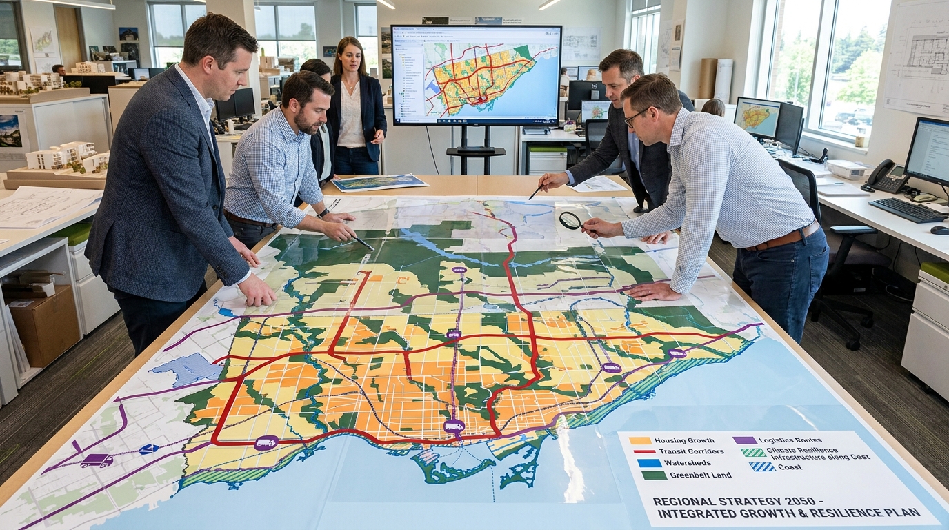
Urban development at mega-region scale rises or falls on infrastructure. Housing may be the most visible outcome, but roads, transit, water, wastewater, energy systems, digital networks, and community facilities determine whether that growth is feasible. Infrastructure also shapes land value. Serviced, connected, and strategically located land can support higher intensity and more productive uses. Land without capacity or access may remain underutilized or become the site of expensive long term bottlenecks.
One of the strengths of mega-region planning is that it allows infrastructure to be prioritized according to regional outcomes rather than local competition alone. Instead of seeing transit investments as isolated municipal projects, planners can assess how corridor improvements unlock housing, expand labour access, reduce congestion, and connect multiple centres. The same is true for water systems, intermodal logistics, and energy distribution. Large scale coordination does not eliminate local needs, but it creates a stronger basis for sequencing public investment where it produces the greatest cumulative benefit.
Transit oriented development is especially important in this framework. When major housing growth is directed toward existing or planned transit corridors, regions can accommodate more people without proportionally increasing road congestion or service costs. This also supports complete communities where daily needs are closer to home. In high growth regions, transit investment and land use planning cannot be treated as separate files. They must be aligned from the outset if the region wants to grow efficiently.
Ontario’s growth planning experience illustrates this principle. Over time, provincial and regional policy has increasingly focused on compact urban form, long range growth management, and serviced development patterns. While implementation is never simple, the underlying logic remains strong. Infrastructure planning works best when it supports a deliberate urban structure rather than reacting after fragmented development has already occurred. At mega-region scale, that discipline becomes even more important because the costs of misalignment multiply quickly.
Sustainability and Climate Resilience at Regional Scale
Mega-region planning matters not only because of growth, but because of the environmental constraints that shape where and how growth can occur. Climate adaptation is now a core urban development issue. Flooding, extreme heat, wildfire smoke, drought pressures, infrastructure failure, and ecological degradation are increasingly influencing project feasibility, municipal budgets, and public safety. These risks do not respect municipal boundaries. They move through watersheds, transportation networks, power systems, and regional landscapes.
That is why climate resilience is one of the strongest arguments for planning at broader scale. Canadian federal policy increasingly links infrastructure investment, land use planning, building standards, and resilience, including climate informed planning and nature based solutions. In practical terms, this means a region must think about how growth affects stormwater systems, floodplains, agricultural land, tree canopy, habitat networks, and emergency response capacity. A development pattern that appears efficient at parcel level can create significant long term risk at watershed or corridor level.
Environmental planning also becomes more effective when integrated with growth strategy. Greenbelts, agricultural lands, river systems, and natural heritage networks are not simply protected areas on a map. They are structural assets that shape regional livability, food security, biodiversity, and climate resilience. Mega-region planning can help define where urban expansion is appropriate, where intensification should be prioritized, and where ecological systems require stronger safeguards. It can also support the use of nature based infrastructure as part of long term servicing strategies.
At the same time, scale alone does not guarantee sustainability. This is a critical caution. Research on megaregions has noted that large urban systems can still produce high emissions, intense vehicle dependence, and growing inequality if policy remains weak. A bigger regional footprint is not the same as a smarter one. Effective mega-region planning must therefore be intentional. It must tie growth to transit, protect environmental assets, coordinate infrastructure investment, and ensure that housing and employment are not pushed into an ever more distant pattern of sprawl.
Economic Vitality and the Logic of Agglomeration
One reason mega-regions are so influential is economic geography. Large urban networks generate what economists call agglomeration benefits. These include bigger labour pools, stronger access to specialized talent, denser innovation networks, more efficient supply chains, and better matching between firms and workers. In development terms, this means land and infrastructure decisions are not only about accommodating population. They are about shaping long term economic productivity.
When metropolitan areas function as connected systems, businesses gain more flexible access to workers, freight corridors, institutional partnerships, and customers. Airports, ports, intermodal hubs, universities, and major employment districts can reinforce one another across the region. This is especially important in North America, where trade corridors and logistics systems play such a central role in economic performance. Mega-region planning supports that connectivity by aligning transportation, employment lands, utility systems, and housing choices more coherently.
But economic strength can also produce spatial imbalance if it is not managed carefully. Opportunity often concentrates faster than affordability. High value employment clusters can drive up land prices, push lower income households farther away, and leave outer areas carrying the burden of housing demand without equivalent infrastructure or services. That is why a serious mega-region strategy must include equity and inclusion as core objectives. Competitive regions are not simply those with strong GDP performance. They are regions that allow people at different income levels to access housing, jobs, transit, and community amenities without extreme tradeoffs.
In this sense, mega-region planning is about more than growth. It is about how growth is distributed. It asks whether the region is building enough homes near opportunity, whether infrastructure is expanding access rather than entrenching exclusion, and whether development supports productive, complete, and resilient communities. That makes it both an economic strategy and a social one.
The Governance Challenge: Coordination Without Gridlock
If the case for mega-region planning is so strong, why is it still difficult to implement. The answer is governance. Most planning systems in Canada and the United States remain organized around municipal, regional, provincial, or state boundaries. Each level of government has its own powers, political pressures, funding tools, and planning priorities. While that structure can support local accountability, it often makes cross boundary coordination slow and inconsistent.
Large urban systems rarely fail because no one understands the need for coordination. They fail because coordination is hard to maintain over time. Municipalities may compete for tax base. Infrastructure agencies may use different planning horizons. Provincial priorities may shift with election cycles. Local opposition may delay regionally important projects. Even when everyone agrees on broad goals such as more housing or better transit, the sequencing of cost, risk, and benefit can remain contested.
This is why mega-region planning should not be presented as a simple new government layer that solves everything. A more realistic and useful framing is that it relies on tools. These include regional growth plans, corridor studies, official plans, secondary plans, transit agencies, housing targets, infrastructure financing programs, watershed based environmental planning, and intergovernmental agreements. The purpose is to align decisions across systems, not to erase all institutional complexity.
The most effective regions tend to develop a shared long term vision and then translate that vision into operational mechanisms. That means data sharing, consistent growth assumptions, linked capital planning, transparent infrastructure priorities, and measurable housing and climate objectives. It also means recognizing that not every issue belongs at mega-region scale. Local urban design, neighbourhood character, and site specific approvals still matter deeply. The key is to distinguish between issues that are local and issues that are inherently regional.
What Effective Mega-Region Planning Looks Like in Practice
For mega-region planning to produce better outcomes, it must move from concept to implementation. That requires a disciplined framework that connects growth management, infrastructure, environmental planning, and market feasibility. In practical terms, successful regional coordination often rests on a handful of recurring strategies that help convert long range vision into development capacity.
-
Establish a clear regional growth structure. Regions need to identify major centres, transit corridors, employment districts, protected natural systems, and strategic areas for future housing supply. This creates the spatial logic that guides both public and private investment.
-
Link housing targets to infrastructure readiness. Ambitious housing goals only matter if land is serviced, approvals are predictable, and transportation capacity is planned in parallel. Regions should prioritize areas where homes can be delivered quickly and sustainably.
-
Use transit oriented development as a default growth model. High capacity transit should anchor substantial residential and mixed use intensification. This reduces long term costs and improves access to jobs and services.
-
Protect environmental systems at watershed scale. Floodplains, river systems, agricultural lands, and green infrastructure networks should be planned as regional assets, not fragmented local constraints.
-
Coordinate infrastructure financing. Development charges, public capital budgets, provincial or federal funding, and utility investment need stronger alignment so growth can be sequenced without chronic delays.
-
Support a diversity of housing forms. Complete regions need high rise housing in major centres, mid rise intensification along corridors, and missing middle formats in established communities. Supply diversity improves both affordability and community stability.
What ties these strategies together is not scale for its own sake. It is the commitment to planning growth where it is economically viable, environmentally responsible, and socially useful. Developers, municipalities, and infrastructure providers all benefit when regional direction is clearer. The private sector can assess land and timing with more certainty. Governments can direct investment with fewer contradictions. Residents gain a stronger basis for understanding how local change fits into a broader future.
Community Needs Still Matter at Larger Scale
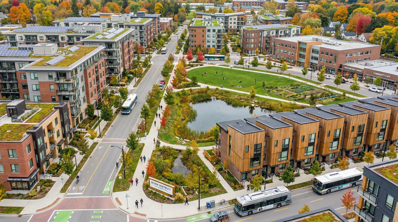
One concern that often arises in discussions about mega-region planning is that it might override local communities. This concern deserves to be taken seriously. Growth cannot be planned effectively if people feel that decisions are being imposed from an abstract regional level with little regard for neighbourhood character, service needs, affordability, or daily quality of life. The best mega-region strategies do not ignore communities. They create the conditions for communities to remain livable as the region grows.
That means planning for schools, parks, healthcare access, local retail, public realm quality, and social infrastructure alongside housing and transit. It also means paying attention to the distribution of growth. If some communities absorb intensification without enough services while others resist change entirely, the region produces both inequity and political backlash. A more balanced regional framework can help spread responsibility, clarify expectations, and tie growth to the community investments needed to support it.
There is also an important cultural dimension. Mega-regions are not anonymous territories. They are made up of places with distinct histories, economies, and identities. A successful planning framework should strengthen those identities by connecting them better, not by flattening them into one generic model. Polycentric growth works best when multiple centres are allowed to evolve as complete communities with their own local anchors and public life.
Ultimately, the measure of success is not whether a region grows larger. It is whether people can live well within that growth. Can they find homes they can afford. Can they reach work without punishing travel times. Can they access parks, schools, healthcare, and local amenities. Can communities remain resilient in the face of climate stress. These are the human questions that regional planning must answer.
The Canadian Opportunity
Canada is well positioned to advance this conversation because many of the underlying building blocks already exist. Metropolitan growth is well documented. Provincial growth frameworks have experience directing urban form. Federal infrastructure and adaptation policy increasingly links resilience with land use and investment. Public debate around housing supply, missing middle housing, transit oriented development, and infrastructure readiness is more active than it has been in years. In other words, the need for mega-region thinking is no longer theoretical. It is embedded in current policy pressures.
The opportunity now is to connect these debates into a more integrated growth agenda. Housing approvals should not be discussed separately from transit capacity. Transit investment should not be detached from land use intensity. Climate adaptation should not be treated as an afterthought to development. Employment strategy should not be disconnected from commuting geography and housing access. Mega-region planning offers a framework for bringing these issues together in a way that reflects how urban systems actually function.
This does not require every part of the country to adopt the same model. Different regions have different geographies, market conditions, governance structures, and environmental constraints. The point is not uniformity. The point is strategic alignment. Fast growing urban corridors need planning methods that match their scale and complexity. In many cases, that means moving beyond isolated municipal solutions and toward more coordinated, long horizon development strategies.
For landowners, developers, investors, planners, and public leaders, this shift has major implications. Regional thinking changes how opportunity is assessed. It places more emphasis on infrastructure sequencing, corridor dynamics, servicing capacity, policy alignment, and long term resilience. It also creates space for more coherent decisions about where to intensify, where to protect, where to invest, and how to deliver housing at the pace required.
Conclusion: Planning at the Scale of Reality
Mega-region planning is not a trend driven by theory alone. It is a response to the fact that city boundaries no longer define the full reality of urban life. In Canada and across North America, the systems that shape housing affordability, mobility, environmental resilience, and economic competitiveness now operate across broader regional networks. Planning must evolve to meet that reality.
The future of urban development will be determined by our ability to coordinate land use, infrastructure, housing, and climate adaptation at the scale where these systems intersect. That does not mean abandoning local planning. It means strengthening it through a clearer regional framework. Municipal decisions matter deeply, but they work best when they support a larger vision for how growth should unfold across the urban system.
For rapidly growing metropolitan regions, the choice is becoming clearer. We can continue to manage growth through fragmented decisions that chase problems after they emerge, or we can plan proactively across the corridors, watersheds, labour markets, and transportation networks that already define modern urban life. The first approach leads to more delay, higher costs, and deeper inequality. The second offers a path toward housing supply, economic vitality, sustainability, and stronger communities.
Mega-region planning is ultimately about planning at the scale of reality. That is why it matters, and why it is likely to shape the next generation of urban development strategy.



No Comment! Be the first one.