Eglinton West Is Becoming a Development Corridor, Not Just a Transit Project
The start of major excavation on four Eglinton Crosstown West Extension stations is more than a construction milestone. It is a land signal. As reported by INsauga, station box work is now underway at Martin Grove Road, Kipling Avenue, Islington Avenue and Royal York Road, moving the 9.2-kilometre extension closer to a planned opening around 2031. For developers, planners and long-term investors, the message is clear: west Eglinton is entering a different development cycle.
Transit projects of this scale do not simply move people. They reorder land value, shift municipal priorities and create a stronger planning rationale for density. The extension will connect Etobicoke and east Mississauga into a nearly 30-kilometre rapid transit spine stretching from Scarborough through Midtown Toronto to Renforth Drive, with a future connection toward Pearson Airport. That is not a local improvement. It is a regional growth framework.
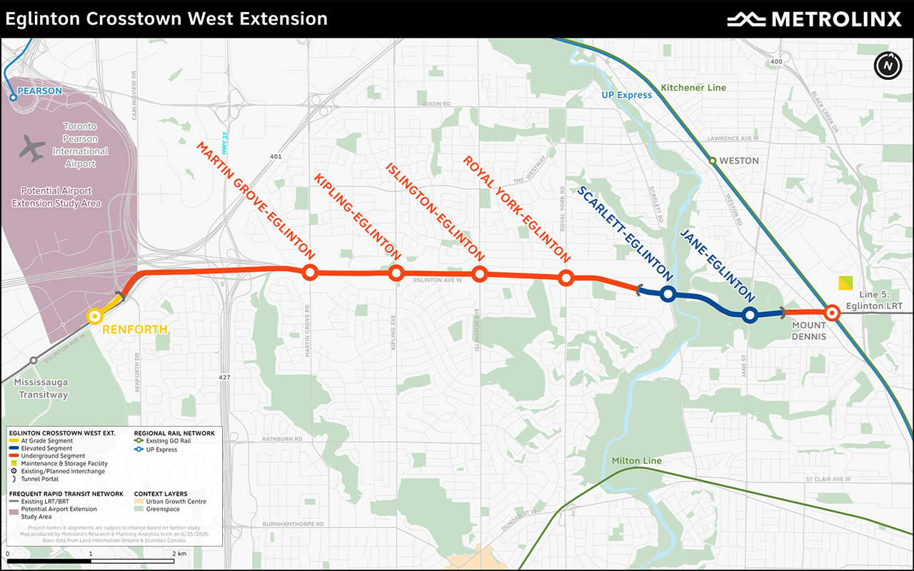
The immediate development question is how quickly zoning, infrastructure capacity and land assembly strategies align with the transit investment. Station areas at Kipling, Islington, Royal York and Martin Grove sit in established corridors where intensification is politically possible but technically complex. Parcels are fragmented. Existing commercial strips, low-rise residential edges and traffic constraints will shape feasibility. The opportunity is real, but it will not be unlocked by transit alone.
What matters now is the sequencing. Excavation confirms that the public sector is moving from promise to delivery. That reduces one of the largest uncertainties in transit-oriented development: whether the infrastructure will actually arrive. As risk declines, expectations rise. Landowners will adjust pricing. Municipal planners will face pressure to permit more housing near future stations. Developers will need to underwrite projects against a corridor that may look very different by the time buildings reach occupancy.
Once station construction begins, the market stops treating transit as theoretical and starts pricing the corridor as future urban infrastructure.
The Renforth node is especially important. It sits at the edge of Mississauga and Toronto, near employment lands, airport-related movement and regional bus connections. If the planned Pearson extension advances, Renforth becomes more than a terminal. It becomes a gateway between airport employment, western GTA commuting patterns and the Eglinton rapid transit spine. That has implications for mixed-use development, institutional demand, rental housing and longer-term office conversion strategies.

The province is positioning the line around commuter relief, job access and emissions reduction, with projected annual greenhouse gas reductions of about 39,000 tonnes. Those are public benefits, but they also support the planning case for higher-intensity land use. If the corridor is expected to carry tens of thousands of daily users, surrounding land policy will need to reflect that investment. Low-density permissions around rapid transit stations will become harder to defend over time.
For developers, the challenge is not simply finding sites near future stops. It is understanding which station areas can absorb density, which will require patient assembly, and which may face infrastructure bottlenecks around roads, servicing, schools and public realm. For municipalities, the issue is whether growth permissions, community services and capital planning can move at the same speed as the transit buildout.

The next five years will determine whether Eglinton West becomes a true transit-oriented growth corridor or simply a better-served arterial. Watch for secondary plan updates, major rezoning applications, land trades near station areas, parking ratio reductions and infrastructure commitments tied to housing targets. The shovels are now in the ground. The development market will not wait until opening day to respond.
Source: INsauga