What Wellington and Portland Tell Us About the Future of Downtown Streets
Every city grows in layers, and the ones that get overlooked most often are the streets themselves. A small redesign at Wellington Street W. and Portland Street in Toronto is proving to be a useful test case for how deliberate infrastructure decisions reshape movement, demand, and ultimately the value of the ground around them.
In June, the city forced a change in how traffic flows through that disjointed downtown intersection, rerouting through-drivers and installing a protected two-way bike lane along Portland. The early results, drawn from city data comparing a single day in June against the same day a year earlier, are striking: cycling crossings up 38 per cent, walking up 20 per cent, and vehicle traffic down 52 per cent. Along Portland itself, pedestrians and cyclists now account for 89 per cent of trips, up from 74 per cent.
For anyone tracking urban growth strategy, this is not simply a transportation story. It is a signal about how a city allocates a scarce resource, its street network, and what that allocation says about where future demand and development pressure will concentrate. When a corridor is deliberately closed off to cut-through driving and opened up to active transportation, the surrounding blocks tend to become more attractive for the kind of density that developers and city planners are chasing: walkable, low car dependency, transit adjacent.
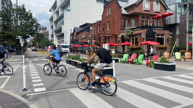
Matti Siemiatycki, director of the Infrastructure Institute at the University of Toronto, framed the shift plainly: good quality pedestrian and cycling infrastructure gets used when it is built properly. That is a lesson worth sitting with for anyone evaluating land near secondary downtown streets. Portland and Dan Leckie Way were chosen specifically because they are secondary roads, not arterials like Bathurst or Spadina, which means the city is testing a model of pushing active transportation onto quieter streets while keeping traffic capacity on the major corridors. That is a repeatable planning template, and it has implications for how nearby parcels get valued and positioned.
We’re trying to balance a scarce resource. If you can create a really vibrant area where thousands of people are moving through, that’s part of the equation.
None of this comes without friction. The city’s own report acknowledges backups on Wellington heading toward Bathurst during evening peak hours, and staff have already tuned traffic light timing once to ease the pressure, moving from four to six vehicles clearing per cycle up to six to eight. That kind of iteration is normal in any large scale infrastructure rollout, and it is exactly the sort of trade-off that land strategists need to factor into feasibility work near reconfigured corridors: reduced car access can raise the appeal of a block for residential and mixed use development even as it complicates last mile logistics for existing businesses.
The bigger takeaway for anyone thinking about long term city growth is this: infrastructure choices made today quietly set the terms for what gets built, and what sells, on the blocks around them tomorrow.
Source: CBC News, “Changes to Portland Street intersection driving cycling, pedestrian activity, data shows”