



Smart cities are often described in terms of apps, sensors, and automation, but the deeper story is about something more practical. It is about making the physical city easier to understand, manage, and improve. Infrastructure data gives governments a way to see roads, transit systems, utilities, public spaces, and environmental risks as living systems that can be measured over time rather than guessed at after problems appear. That shift matters because modern urban challenges are rarely isolated. Congestion affects emissions and productivity. Aging water pipes affect costs, service continuity, and public trust. Flooding affects transportation, housing, insurance, and emergency response at the same time.
Table Of Content
- What Infrastructure Data Means in a Smart City Context
- Why Cities Need Better Infrastructure Visibility
- The Technologies Behind Smart Infrastructure Data
- How Infrastructure Data Improves Transportation and Mobility
- Beyond Traffic Apps: The Hidden Value in Operations
- Infrastructure Data and the Shift to Integrated Urban Management
- Why Climate Resilience Is Now Central to Infrastructure Data Strategy
- The Role of Data Governance, Privacy, and Public Trust
- Open Data and Interoperability Matter More Than Ever
- How Canadian Policy Has Framed Smart Cities Around Outcomes
- Common Misconceptions About Smart City Infrastructure Data
- What Effective Infrastructure Data Strategy Looks Like
- The Future of Smart Cities Will Be Measured in Decisions, Not Devices
Across Canada and other advanced urban economies, infrastructure data has become a core input for smarter planning and better operations. The federal Smart Cities Challenge, launched in 2017, pushed communities to define measurable outcomes and use data and connected technology to achieve them. The program offered $75 million in prizes and, more importantly, helped establish a national model that linked urban innovation to resident well being rather than to technology for its own sake. This outcomes based approach is one reason the smart city conversation has matured. The most useful question is no longer whether a city has smart tools. It is whether those tools make mobility safer, maintenance more efficient, planning more accountable, and daily life more reliable.
That makes infrastructure data one of the most important layers in modern urban intelligence. It supports real time awareness, long term investment planning, climate resilience, and service coordination across departments that have traditionally worked in silos. It also comes with real governance questions. A city that collects more data without clear standards, privacy safeguards, public oversight, and interoperability can end up with fragmented dashboards, vendor lock in, or distrust instead of better outcomes. Smart city success depends as much on governance and design as on hardware and software.
This article explores how infrastructure data is shaping smart cities in practical terms. It looks at the technologies behind collection and analysis, the most valuable use cases in transportation and urban management, the role of digital twins and predictive systems, and the governance principles that determine whether a city becomes more responsive or merely more monitored. The central point is simple. Infrastructure data is not just about making cities smart. It is about making them legible, accountable, and adaptable.
What Infrastructure Data Means in a Smart City Context
Infrastructure data refers to the information generated by the built systems that keep a city functioning. That includes transportation networks, bridges, traffic signals, public transit, water systems, stormwater infrastructure, energy assets, street lighting, public buildings, cycling networks, and environmental monitoring systems. Some of this information comes from sensors and connected devices. Some comes from inspections, maintenance records, administrative systems, satellite imagery, geospatial databases, and open government data portals. When these sources are brought together, cities can begin to understand not only what assets exist, but how they are performing and where risk is building.
In older municipal models, infrastructure was often managed through periodic reviews, paper records, and department specific software. A road team had one set of records, the transit agency had another, the utilities department had its own mapping layers, and emergency management worked from a different operational picture. That fragmentation made it difficult to see how one issue could cascade into another. A water main break might disrupt traffic and bus service, but if data systems are not linked, the city reacts slowly and residents receive inconsistent information.
Smart city infrastructure data changes that by creating a more integrated view. A city can combine GPS feeds from buses, congestion data from roads, environmental readings from air quality sensors, and geospatial layers showing drainage systems and flood prone areas. Once linked, those systems support a much richer decision environment. Officials can see where delays are increasing, where pavement is deteriorating, where drainage capacity is under pressure, and where intervention is likely to deliver the strongest public value.
This is why smart city discussions increasingly focus on urban intelligence rather than devices alone. Sensors matter, but they are only one part of the chain. The real value appears when data becomes operationally useful, analytically reliable, and institutionally trusted. A city becomes smarter when it can turn infrastructure data into timely maintenance, clearer public communication, safer streets, and better capital planning.
Why Cities Need Better Infrastructure Visibility
Cities are under pressure from both growth and aging systems. In many regions, demand for housing and mobility continues to increase while roads, pipes, bridges, and public facilities age beyond their originally intended service life. At the same time, climate volatility is exposing weaknesses that older planning assumptions did not fully account for. A storm that overwhelms drainage systems can close roads, damage homes, and disrupt transit within hours. Without reliable infrastructure data, cities are forced to respond reactively, which is usually more expensive and less effective.
Operational awareness is one of the clearest reasons infrastructure data matters. Municipal teams need to know what is happening right now, where it is happening, and how conditions are changing. This includes traffic congestion, service interruptions, asset failure risks, crowding in transit corridors, air quality spikes, and localized flooding. Real time visibility helps cities move from after the fact problem solving to earlier intervention. That can reduce costs, shorten delays, and improve the resident experience in ways that are visible almost immediately.
But visibility is not only a real time issue. Long term infrastructure planning depends on historical performance data and spatial context. If a city knows which roads require repeated repairs, which intersections experience recurring incidents, or which neighborhoods face repeated drainage stress, it can prioritize capital spending more rationally. Evidence based planning allows limited budgets to be directed toward the assets and locations where social and economic returns are likely to be highest.
There is also a public accountability dimension. Residents often see municipal infrastructure as either working or failing, with little insight into tradeoffs, backlog, or system complexity. Data can improve that relationship if it is used transparently. Public dashboards, open datasets, and measurable targets make it easier for communities to understand what the city is trying to improve and whether it is making progress. In that sense, infrastructure data supports not only operational efficiency but also democratic clarity.
The Technologies Behind Smart Infrastructure Data
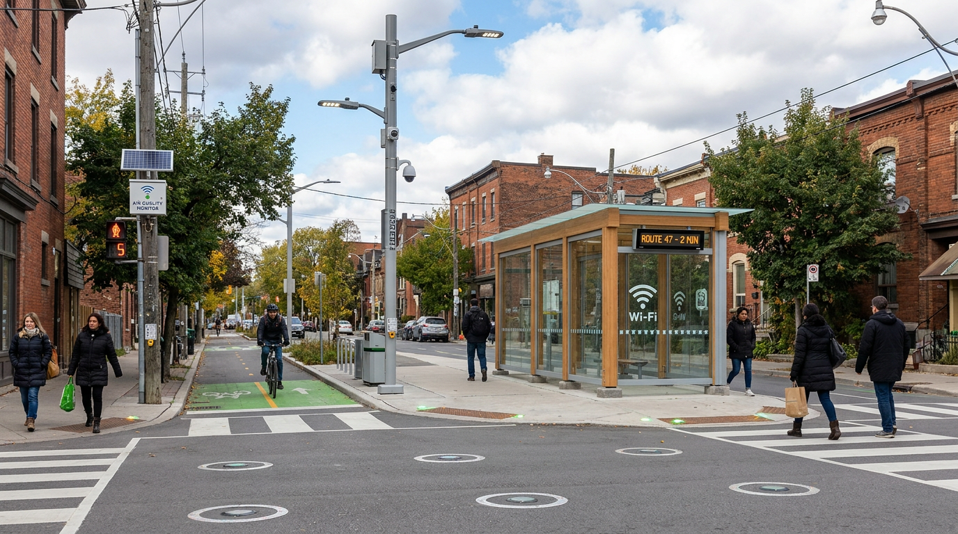
The technology stack behind infrastructure data has expanded rapidly over the past decade. At the foundation are the physical collection tools. These include IoT sensors embedded in roads and bridges, cameras at intersections, GPS systems on transit fleets, parking sensors, weather stations, water pressure monitors, flood gauges, and air quality devices. Smart poles can combine several of these functions in one location, serving as compact nodes for environmental and traffic monitoring. Together, they turn static urban infrastructure into a source of continuous signals.
Geospatial systems provide another critical layer. Maps are not just visual aids in this context. They are organizing frameworks that link asset location, condition, service area, and environmental context. Geographic information systems allow planners and operators to see where infrastructure sits in relation to population density, land use, transit demand, vulnerable communities, and hazard exposure. Statistics Canada has been expanding infrastructure related data resources, including a Canadian Cycling Network Database through its Urban Data Lab, which shows how even mode specific assets can become part of richer planning systems.
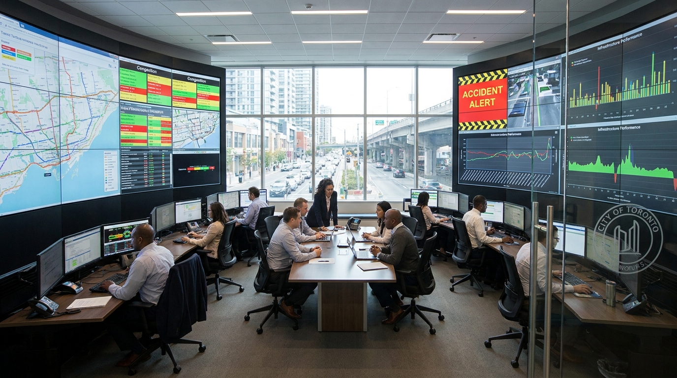
Cloud computing and integrated data platforms make it possible to store, standardize, and share information across departments. This shift away from isolated systems is one of the defining smart city trends. Instead of each agency maintaining separate and incompatible datasets, cities are increasingly building platform based architectures or operations centers that can combine multiple feeds into one environment. When done well, this improves interoperability and reduces duplication. When done poorly, it can create new silos hidden behind sleek interfaces. The architecture matters as much as the dashboard.
Artificial intelligence and machine learning add an intelligence layer on top of these systems. AI models can identify patterns in traffic flows, predict maintenance needs, classify incidents from video, estimate infrastructure deterioration, and simulate operational responses. The key here is not to imagine AI as a replacement for planning judgment. It is better understood as a tool for pattern recognition and prioritization. In complex urban systems, the ability to detect anomalies or forecast probable failure can help staff act faster and allocate resources more effectively.
One of the most ambitious developments is the rise of digital twins. A digital twin is a virtual representation of physical infrastructure or an entire urban environment that updates with real world data. It can be used to test scenarios, evaluate tradeoffs, and model how one system affects another. A city might use a digital twin to understand how a road closure changes traffic patterns, how a flood event stresses transportation and drainage assets, or how new development could affect utility capacity. This moves planning from static forecasting toward adaptive simulation.
How Infrastructure Data Improves Transportation and Mobility
Transportation is often the most visible smart city use case because mobility produces large volumes of dynamic data and affects daily life directly. Cities can collect information from traffic signals, cameras, roadway sensors, transit smart cards, vehicle GPS, parking systems, cycling network maps, and pedestrian counters. This allows transportation teams to understand demand, identify bottlenecks, adjust operations, and improve traveler information in real time.
World Bank research has consistently highlighted transit, traffic, and infrastructure operations as leading urban data use cases. The reason is straightforward. Mobility systems are interdependent and time sensitive. A small disruption at one node can spread quickly through surrounding corridors. Real time data allows cities to manage incidents more effectively, reroute traffic, provide accurate public updates, and identify where service changes are needed. In practice, this can mean reducing bus bunching, improving signal timing, responding faster to collisions, or optimizing lane management during peak periods.
Seoul’s TOPIS system remains one of the best known examples of integrated urban mobility intelligence. It collects traffic and infrastructure information across transportation modes and uses that data for both real time traveler information and long range planning. What makes this example valuable is not simply its scale. It shows how the same dataset can support multiple objectives at once. Operations teams use it to manage current conditions, while planners use historical patterns to shape future investments.
For residents, the value of infrastructure data in mobility is often experienced in small but meaningful ways. Better predictions on arrival times reduce uncertainty. Faster response to breakdowns or congestion reduces wasted time. Improved cycling network data can support safer route planning and stronger multimodal integration. Smarter curb and parking management can reduce cruising traffic. These may seem incremental, but across a metropolitan region they compound into measurable gains in productivity, safety, and emissions reduction.
It is also important to note that transportation data is not only about convenience. It can support more inclusive planning. Data on route reliability, stop accessibility, sidewalk conditions, and neighborhood connectivity can reveal where infrastructure fails to serve older adults, people with disabilities, lower income commuters, or communities that rely heavily on transit. When cities use infrastructure data to identify mobility inequities, smart city planning becomes more than optimization. It becomes a tool for fairer access.
Beyond Traffic Apps: The Hidden Value in Operations
One common misconception is that smart mobility is mainly about consumer facing apps. Those tools matter, but much of the highest value sits behind the scenes. Infrastructure data helps transportation agencies manage fleets, schedule maintenance, coordinate signal systems, monitor bridges and roads, and prioritize future capital works. A transit rider may never see the analytics model that improved reliability on a corridor, but they will feel its effect through shorter waits and fewer disruptions.
This hidden operational value is especially important for mid sized cities that may not have the budgets of major global metros. They do not need to build futuristic control centers to benefit from better data. Even modest systems that combine open transit feeds, road condition reports, weather data, and GIS layers can materially improve service planning and infrastructure prioritization. The smart city model is increasingly relevant to communities of all sizes because scalable tools and open data frameworks are making adoption less expensive.
Infrastructure Data and the Shift to Integrated Urban Management
The most significant smart city trend is the move from siloed infrastructure systems toward integrated urban management. Roads, public transit, utilities, emergency services, environmental monitoring, and public works have historically been run as separate domains. Each built its own workflows and technologies. That structure made sense administratively, but it often failed operationally because cities function as connected systems rather than separate departments.
Integrated operations centers and citywide data platforms aim to solve this problem by creating a shared view of conditions across departments. A severe rainfall event, for example, does not affect only stormwater infrastructure. It can disrupt roads, buses, emergency access, public safety communications, and vulnerable housing areas. If teams are looking at disconnected systems, response will be slower and less coordinated. If they share the same spatial and operational picture, response can be prioritized more intelligently.
This integrated model also improves maintenance coordination. If a city knows a road segment is due for resurfacing, a utility upgrade is planned beneath it, and transit service changes are expected nearby, those projects can be sequenced in a way that reduces repeat disruption and controls cost. Infrastructure data helps reveal these overlaps. Instead of treating each intervention as separate, cities can act on the logic of the wider system.
The same principle applies to capital planning. A city that combines demographic trends, mobility demand, asset condition data, and climate risk layers can make stronger investment decisions than one relying on asset age alone. Infrastructure does not fail in a social vacuum. Its importance depends on who uses it, what it connects, how exposed it is to hazards, and what other systems depend on it. Integrated data architecture makes those relationships visible.
Smart city success is not defined by how many sensors a municipality deploys. It is defined by whether infrastructure data helps public agencies make faster, fairer, and more resilient decisions.
Why Climate Resilience Is Now Central to Infrastructure Data Strategy
Climate resilience has become one of the strongest reasons for cities to invest in infrastructure data. Flooding, heat, freeze thaw cycles, wildfire smoke, and extreme storms all affect urban systems in ways that can no longer be treated as rare exceptions. Infrastructure data gives cities the ability to detect, monitor, and respond to these conditions with more precision. That matters for public safety, service continuity, and long term asset preservation.
Flood risk is a useful example. If drainage networks, topography, rainfall intensity, road sensors, and historical incident data are brought together, a city can identify where water is likely to accumulate before a major event occurs. Real time monitoring can trigger road closures or service warnings more quickly, while historical analysis can support upgrades to culverts, storm sewers, and vulnerable corridors. This is one reason smart city approaches are increasingly tied to adaptation rather than only to efficiency.
Environmental sensing also supports public health and quality of life. Air quality monitors, heat sensors, and localized weather data can show how urban conditions vary by neighborhood. That helps cities target tree planting, cooling strategies, traffic changes, and public communication more effectively. Climate impacts are often unevenly distributed, and infrastructure data helps make that unevenness visible.
Long term resilience depends on maintenance prioritization as much as emergency response. Roads exposed to repeated freeze thaw stress, bridges facing heavy usage and temperature variation, or water systems under changing groundwater conditions all require more adaptive asset management. Data makes it easier to shift from fixed maintenance cycles toward risk based maintenance. That means scarce funding can be directed where likely failure and social consequence are both highest.

The Role of Data Governance, Privacy, and Public Trust
No discussion of infrastructure data in smart cities is complete without governance. In fact, governance may be the difference between a useful urban intelligence system and a failed public experiment. OECD research has warned that smart city data systems can increase surveillance concerns, reduce public participation, and concentrate control if governance is weak or overly centralized. Canadian debates around high profile smart city proposals have shown that public trust can erode quickly when residents do not know who owns the data, who benefits from it, or how it will be used.
This is why data governance has moved to the center of smart city strategy in Canada and elsewhere. Governance covers privacy, security, ownership, standards, access rights, accountability, retention policies, procurement design, and citizen engagement. Canada has also issued national security guidance that recommends integrating data governance and security across the entire smart city lifecycle, including design, operation, and decommissioning. That framing is important because security is not a feature added at the end. It is part of the system architecture from the beginning.
Strong governance does not slow innovation. It enables sustainable innovation. If departments use common data standards and interoperability rules, they can share information more effectively. If contracts address portability and ownership clearly, cities are less likely to become trapped in vendor ecosystems that are expensive to maintain or difficult to replace. If residents understand how data supports better services and what safeguards exist, they are more likely to support digital infrastructure investment.
Public trust also depends on proportionality. Not every urban problem requires the most intrusive possible data collection method. Cities need to ask whether a specific type of data is necessary, whether less invasive alternatives exist, and how long information should be retained. Smart city programs become more legitimate when they are tied to clearly defined outcomes and transparent evaluation rather than broad claims about innovation. An outcomes based model gives residents a way to judge whether the tradeoffs are worthwhile.
Open Data and Interoperability Matter More Than Ever
One of the less visible but most important trends in smart city development is the push for open data and interoperability standards. Infrastructure data becomes more valuable when it can be reused across departments, by researchers, and by civic technology communities. Open standards make that possible. They also reduce the risk that a city invests heavily in one platform only to discover it cannot easily integrate new tools later.
Interoperability is especially important as data volumes grow. Traffic systems, utility sensors, land use datasets, and climate monitoring tools often come from different vendors and operate on different update cycles. Without shared standards and metadata discipline, integrated analytics become unreliable. In practical terms, this means a city can have more dashboards than ever and still understand less than it should. More data does not automatically create better urban outcomes. Quality, compatibility, and governance matter just as much.
How Canadian Policy Has Framed Smart Cities Around Outcomes
Canada’s smart city policy environment has been notable for emphasizing resident outcomes rather than pure technical modernization. The Smart Cities Challenge invited communities to define measurable challenge statements and then use data and connected technology to address them. This may sound procedural, but it has significant implications for how infrastructure data is used. Instead of asking what technology a city wants to buy, the model asks what public result a city needs to improve and what evidence can track progress.
This outcomes based framing also helped widen participation beyond the largest metropolitan areas. Smart city strategies are not only for global financial centers with massive innovation budgets. Mid sized cities, rural regions, and Indigenous communities can use infrastructure data to improve mobility, service access, environmental monitoring, and public communication in ways that fit local scale. The OECD has noted that in Canada the term smarter communities is sometimes used to emphasize innovation and connected technology as tools for strengthening communities and creating growth opportunities rather than only building highly digitized urban cores.
That broader framing matters because infrastructure challenges vary widely across place. A dense downtown may focus on transit reliability and curb management. A regional municipality may focus on road maintenance, flood visibility, and utility resilience across large geographies. A smaller community may prioritize broadband enabled service coordination and lower cost asset management. In each case, infrastructure data can support smarter decisions, but the implementation model should reflect local needs and institutional capacity.
Common Misconceptions About Smart City Infrastructure Data
There are several misconceptions that distort the public conversation around infrastructure data. The first is the idea that more data automatically creates better decisions. In reality, bad data quality, weak governance, fragmented systems, and unclear accountability can produce noise rather than insight. Cities need processes that turn data into action, not just systems that collect more of it.
The second misconception is that smart cities are only for large and wealthy urban centers. Canadian policy and recent technology trends show the opposite. Cloud tools, open geospatial resources, and lower cost sensors have expanded what smaller communities can do. A town does not need a futuristic command center to use infrastructure data well. It needs clear objectives, reliable baselines, and a governance model suited to its scale.
The third misconception is that smart city technology is mostly about convenience apps. In practice, some of the highest value comes from asset management, maintenance planning, service coordination, resilience, and long term capital allocation. Residents may see the front end app, but the real gains often come from the back end systems that make service delivery more coherent.
The fourth misconception is that a smart city is automatically a surveillance city. The risk is real if governance is poor, but the two are not synonymous. Citizen centered smart city projects can improve mobility, maintenance, and emergency response while minimizing unnecessary personal data collection. The difference lies in design choices, oversight, and public accountability.
What Effective Infrastructure Data Strategy Looks Like
An effective infrastructure data strategy usually begins with a narrow but meaningful question. Which services are under strain. Which assets are failing too often. Which neighborhoods face repeat disruption. Starting with these questions keeps technology tied to operational need. It also helps define the metrics that matter, whether that is transit reliability, response time, flood incident frequency, maintenance backlog reduction, or emissions change.
From there, cities need a practical framework that connects data collection, governance, integration, and decision making. The strongest strategies share several characteristics.
- They define resident centered outcomes before selecting tools.
- They use interoperable data standards and avoid unnecessary platform lock in.
- They combine real time operational data with long term planning data.
- They build privacy, security, and retention rules into the system from the start.
- They create governance structures that clarify ownership, access, and accountability.
- They make progress visible through reporting, dashboards, or open data where appropriate.
Just as important, effective strategies are iterative. Cities do not become data driven in a single procurement cycle. They mature over time by improving data quality, expanding integration, training staff, refining metrics, and adjusting systems based on public feedback. The best smart city programs are less about a dramatic technological leap and more about building a durable operational capability.
The Future of Smart Cities Will Be Measured in Decisions, Not Devices
Infrastructure data is becoming the intelligence layer behind modern urban management. It helps cities observe what is happening now, understand what has happened before, and model what could happen next. That capability is increasingly essential as municipalities face growth pressure, aging assets, climate volatility, and higher public expectations. Roads, utilities, transit systems, and environmental networks can no longer be managed effectively with fragmented visibility and delayed feedback.
The next phase of smart city development will likely deepen the use of digital twins, predictive maintenance, integrated operations centers, and AI supported planning. But the most successful cities will not be the ones with the most sensors or the most ambitious branding. They will be the ones that turn infrastructure data into better judgment. That means faster operational response, stronger cross department coordination, clearer investment priorities, and more transparent public outcomes.
For Canada and for cities globally, the lesson is increasingly clear. Smart city infrastructure data is valuable not because it makes urban systems look advanced, but because it makes them easier to govern well. When combined with sound standards, public trust, and measurable goals, data can help cities reduce congestion, improve transit reliability, target maintenance, detect climate risks, and plan more inclusively. In that form, infrastructure data does more than digitize the city. It helps the city learn.
That is the real promise of urban intelligence. A city that can see itself more clearly can serve its residents more effectively. And in a time when every infrastructure decision carries financial, environmental, and social consequences, that clarity is no longer optional. It is becoming basic urban capacity.


No Comment! Be the first one.